I specialize in designing outdoor recreation maps. My services offer a simple, clean, and attractive solution to those with cartographic design needs. I offer a holistic, all inclusive, Maine to California service that includes everything from photo editing to graphic design, data collection to fine map edits, brochure design to brochure printing, and more.
Listed below are some projects that I have completed under freelance contracts.
Bike Bucks County Cycling Web Map (February 2019)
Web Map - Bucks County, Pennsylvania
This map was developed through a project between offthemaps and Bike Bucks County - part of the Bicycle Coalition of Greater Philadelphia. The web map is made to aid cyclists with ride planning in Buck’s County, Pennsylvania. The map has an outdoor theme with contour lines to view elevation easily. It includes functionality to toggle on and off amenities that are important to cyclists like bike shops, breweries, covered bridges, and more!

D&L Trail Lehigh Valley Region Map (April 2018)
24" x 16" Map & Guide - Lehigh Valley, PA
The latest D&L Trail Map. This is a trail map that I designed while working as an employee for the Delaware & Lehigh National Heritage Corridor. This map was an improvement upon the last D&L Trail Map. It now includes locations of trailheads by lat/lon coordinates along with a little tutorial on how to use a smartphone as a GPS. Pick one up if you are in the area - they are free!

Lackawanna River Heritage Trail Map & Guide (February 2018)
24" x 16" Map-Brochure - Scranton, Pennsylvania
This map was developed through a project between offthemaps and the Lackawanna Heritage Valley National and State Heritage Area. The map helps trail users explore over 40 miles of trail that stretch north from Scranton toward the PA/NY border. Notice that the watershed is highlighted in multiple areas to indicate the connection between the trail and river.

Two Rivers Trailway Cycling Map (September 2017)
36" x 48" Map-Panel - Easton, Pennsylvania
This map-panel was developed through a project between offthemaps and The City of Easton. Easton was where I was residing at the time the map was made, and so designing this map struck close to home. It allowed me to better explore cycling paths and routes through the Greater Easton Area in order to better share those places with others. These routes follow the Lehigh River & Canal, Delaware River & Canal, and the Bushkill Creek. This map provides the information for urban residents to explore the city or quickly escape urbanity on one of its many greenways.

Bucks County Cycling Map (October 2017)
24" x 16" Map-Brochure - Bucks County, Pennsylvania
This map / brochure is the second collaborative project between offthemaps and Bike Bucks County. It is the only map of it's kind I have seen to date in print and made for quite the challenge. This map includes the entire extent of Bucks County, Pennsylvania - a paradise for road cyclists who want to pedal rolling country roads through rural Pennsylvania. These rides are packed with gentlemen's farms, covered bridges, and other historic remnants of American History.

The goal of this map was to provide road cyclists who are unfamiliar with the area the proper information to make an excellent road ride. What data does the map contain - PennDOT Average Daily Traffic, Elevation (hillshade), B&Bs, Covered Bridges, Wineries, Breweries, Bike Shops, and more points of interest - everything a rider needs! Planning a road ride can be difficult if one is unfamiliar with the area. To feel safe, it's almost always necessary to have a friend, stop at a bike shop, get a cue sheet, or buy a guide book with specified routes. This brochure is free and allows visitors and residents to choose their own adventure or add to a ride they've been doing for years.
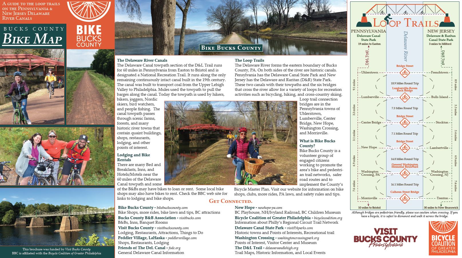
Bike Bucks County Loops (March 2017)
9" x 16" Map-Brochure - Eastern Bucks County, Pennsylvania
This map / brochure is the first of many collaborative projects between offthemaps and Bike Bucks County. It aids trail users of all sorts plan single or multi-day trips on the D&L and D&R Trails along the Delaware River.


Delaware Canal Region Map (December 2016)
24" x 16" Map-Brochure - Eastern Bucks County, Pennsylvania
This is map 1 of the 4-part D&L Trail Map series that covers the entire Delaware and Lehigh National Heritage Corridor. It was made to help users navigate the trail and explains some history along the way. For more information, check out the Delaware & Lehigh National Heritage Corridor on the web.

Anthracite Region Map (August 2016)
24" x 16" Map-Brochure - Carbon & Luzerne County, Pennsylvania
This is map 3 of the 4-part D&L Trail Map series that covers the entire Delaware and Lehigh National Heritage Corridor. It was made to help users navigate the trail and explains some history along the way. For me, this was an A to Z project. I collected over 100 miles of trail data, designed the map, took some of the photos, and designed the full layout. For more information, check out the Delaware & Lehigh National Heritage Corridor on the web.
The Younger Dryas Event (December 2015)
This map describes the difference in land cover in Europe during the Younger Dryas Event. It was done as an optional project during my Climatology class in college. It was recently picked up by phys.org - check out the article here!
